
geodezie, geodetické práce, geodetické plány geometrický plán, zeměměřič, geodetické zaměření pozemku a stavby, katastr nemovitostí
Contact:
Ing. Svatopluk Bernard
U Trojice 797/21
370 04 České Budějovice 4
Office:
Lidická 15/119
370 01 České Budějovice
beige building across the bus stop, 3rd floor, ring the bell next to the entrance from the street
φ14°28'31,3"
λ48°58'3,8"
e-mail:
svatopluk.bernard@geotera.cz
(katos11@yahoo.com)
phone 1: +420 605 118 385
phone 2: +420 606 258 481
φ14°28'31,3"
λ48°58'3,8"
e-mail:
bernard@geo-bernard.com
(katos11@yahoo.com)
Reg.Nr.: 72150777

We've expanded and now you'll find us under the Geotera company header

Contents
When and where will you need a surveyor?
What is a survey sketch and what is it used for?
Requisites for recording a building in the Cadastre of Real Estates
Requisites for recording a building under construction in the Cadastre of Real Estates
Geodetic works in capital construction
Consulting – GPS, DMT, GIS, photogrammetry, FM and Remote sensing
When and where will you need a surveyor?
- First time, you will need a surveyor for locating the lines of an area or for the creation of the survey sketch for the plot partition
- Next time, you will need him to locate the future building (e.g. a family house according to the project)
- Possibly, you will need a survey sketch of the building under construction for the loan
- Survey sketch for the record into the Cadastre of Real Estates can be made while the first floor disposition is clearly visible (the building does not need to be completed)
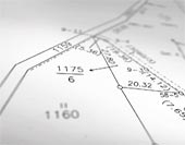
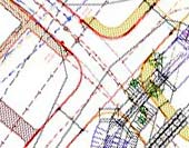
What is a survey sketch and what is it used for?
- Survey sketch is a result of geometric works
- It is made when there is a change on your parcel, which has to be written down in the Cadastre of Real Estates
- It is a technical base for the record in the Cadastre of Real Estates and is an inseparable part of various documents (Certificate of practical completion, Resolution about house number allocation, Purchase agreement, Order of the court etc.) leading to the record in the Cadastre of Real Estates
- The owner of the parcel which has undergone a change has to ask for the entry in the Cadastre
Survey sketch is made for:
- Construction bearing
· buildings under construction - for obtaining a mortgage credit
· completed buildings before substantion inspection – new buildings, additions, garages, etc.
- Easement setting-up
needed in case that the easement is only on the part of a parcel. The range of the easement will be marked in the graphic part of the survey sketch (and thus will not be a part of the cadastral map)
- Parcel separation
in this case you need the permission of the competent municipal office and construction administration for the separation; otherwise, this separation cannot be recorded into the Cadastre of Real Estates
- Restoration and location of property boundaries
· the boundary marked in the cadastral map is transmitted into grounds
· boundaries are located according to the corresponding survey documents and technical data saved at Cadastre of Real Estates
· boundary points are marked with specified boundary marks (plastic landmarks etc.)
· the result has to be delivered to owners of all adjoining parcels – they can express their agreement or disagreement with the boundary line
Requisites for recording a building in the Cadastre of Real Estates
- Application for entering the building to the competent Cadastral office
- Certificate of practical completion (certified copy with clause about legal validity)
- Resolution about house orientation number / control number allocation
- Survey sketch (draft copy) with the building marked
Requisites for recording a building under construction in the Cadastre of Real Estates
- application for entering the building to the competent Cadastral office
- planning and building permission (certified copy with clause about legal validity)
- survey sketch (draft copy) with the building marked
- statutary declaration of promoters, that they are the owners of the building under construction, certified signs
Note: There can be some little differences in these requisites at some Cadastral Offices
You can download the blanks you will need for the procedure s in the Download section.

Geodetic work in capital construction
In survey engineering, I can help you with the following activities:
- geodetic works in capital construction – responsible surveyor’s work guarantee
- locating of monolith and system buildings
- check-up survey during the construction
- buildings deformation monitoring
- survey of actual constructions of distribution systems, line constructions and buildings
- actual construction documentation

Other special geodetic work
Besides the work for the Cadastre of Real Estates and survey engineering I also offer specialized work connected with geodesy. For more information please see the Service section, or contact me for more details.
- purpose surveying, creating and editing of altimetric and planimetric data for design activities
- output in classic and digital format, any size
- setting up and completion of the horizontal control
- all surveying required for projecting and realization of land adjustment
^ top

Consulting – GPS, DMT, GIS, photogrammetry, FM and Remote sensing
If you are to build a geoinformatic system, you will often deal with the above mentioned terms. I can help you in all of these fields and propose and design the most effective solution, which will use your current resources as well as respect your limits.
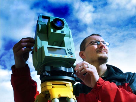
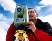
Global positioning system (GPS) is a system of position identification through the satellites. You can use the geodetic plant or the much more cheaper touristic recievers.
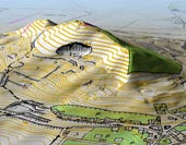
Landscape digital model (LDM) is a file of geodata (geodetic points, lines and areas) which describe curves of the terrain relief. LDM allows for effective solution of many types of area- and space related tasks. For more information see the Service section.
LDM preparation and adjustment is a fundamental part of digital orthophotomaps creation. These maps belong to the the basic level of geoinformatics systems (GIS), which can make the work with space data easier.
I offer consultations and advice on how to build up your own GIS; how to choose suitable software, how to choose and get source data. With the help of GIS, you can easily prepare documents for administrative procedures or development projects. GIS data also allow for simulation of processes and effects in a specified area. Local authorities and larger companies are obliged to create their own GIS.
Photogrammetry (aerial pictures) is a basic means of information retrieval for making decisions about a specific area.Thanks to the Remote sensing we can find out a lot of interesting information about the position and condition of the object. Photogrammetric and RS data are used while creating GIS. I can provide such data and help you with their application.
Facility management (FM) is a discipline specialized in the optimization of supportive processes in a company with respect to its economy and organization. A land surveyor will help you with the real estate control and useful applications of data from the Cadastre of Real Estate.

Contact:
Ing. Svatopluk Bernard
U Trojice 797/21
370 04 České Budějovice 4
Office:
Lidická 15/119
370 01 České Budějovice
beige building across the bus stop, 3rd floor, ring the bell next to the entrance from the street
φ14°28'31,3"
λ48°58'3,8"
e-mail:
svatopluk.bernard@geotera.cz
(katos11@yahoo.com)
phone 1: +420 605 118 385
phone 2: +420 606 258 481
φ14°28'31,3"
λ48°58'3,8"
e-mail:
bernard@geo-bernard.com
(katos11@yahoo.com)
Reg.Nr.: 72150777
We've expanded and now you'll find us under the Geotera company header
Contents
When and where will you need a surveyor?
What is a survey sketch and what is it used for?
Requisites for recording a building in the Cadastre of Real Estates
Requisites for recording a building under construction in the Cadastre of Real Estates
Geodetic works in capital construction
Consulting – GPS, DMT, GIS, photogrammetry, FM and Remote sensing
When and where will you need a surveyor?
- First time, you will need a surveyor for locating the lines of an area or for the creation of the survey sketch for the plot partition
- Next time, you will need him to locate the future building (e.g. a family house according to the project)
- Possibly, you will need a survey sketch of the building under construction for the loan
- Survey sketch for the record into the Cadastre of Real Estates can be made while the first floor disposition is clearly visible (the building does not need to be completed)
What is a survey sketch and what is it used for?
- Survey sketch is a result of geometric works
- It is made when there is a change on your parcel, which has to be written down in the Cadastre of Real Estates
- It is a technical base for the record in the Cadastre of Real Estates and is an inseparable part of various documents (Certificate of practical completion, Resolution about house number allocation, Purchase agreement, Order of the court etc.) leading to the record in the Cadastre of Real Estates
- The owner of the parcel which has undergone a change has to ask for the entry in the Cadastre
Survey sketch is made for:
- Construction bearing
· buildings under construction - for obtaining a mortgage credit
· completed buildings before substantion inspection – new buildings, additions, garages, etc.
- Easement setting-up
needed in case that the easement is only on the part of a parcel. The range of the easement will be marked in the graphic part of the survey sketch (and thus will not be a part of the cadastral map) - Parcel separation
in this case you need the permission of the competent municipal office and construction administration for the separation; otherwise, this separation cannot be recorded into the Cadastre of Real Estates - Restoration and location of property boundaries
· the boundary marked in the cadastral map is transmitted into grounds
· boundaries are located according to the corresponding survey documents and technical data saved at Cadastre of Real Estates
· boundary points are marked with specified boundary marks (plastic landmarks etc.)
· the result has to be delivered to owners of all adjoining parcels – they can express their agreement or disagreement with the boundary line
Requisites for recording a building in the Cadastre of Real Estates
- Application for entering the building to the competent Cadastral office
- Certificate of practical completion (certified copy with clause about legal validity)
- Resolution about house orientation number / control number allocation
- Survey sketch (draft copy) with the building marked
Requisites for recording a building under construction in the Cadastre of Real Estates
- application for entering the building to the competent Cadastral office
- planning and building permission (certified copy with clause about legal validity)
- survey sketch (draft copy) with the building marked
- statutary declaration of promoters, that they are the owners of the building under construction, certified signs
Note: There can be some little differences in these requisites at some Cadastral Offices
You can download the blanks you will need for the procedure s in the Download section.
Geodetic work in capital construction
In survey engineering, I can help you with the following activities:
- geodetic works in capital construction – responsible surveyor’s work guarantee
- locating of monolith and system buildings
- check-up survey during the construction
- buildings deformation monitoring
- survey of actual constructions of distribution systems, line constructions and buildings
- actual construction documentation
Other special geodetic work
Besides the work for the Cadastre of Real Estates and survey engineering I also offer specialized work connected with geodesy. For more information please see the Service section, or contact me for more details.
- purpose surveying, creating and editing of altimetric and planimetric data for design activities
- output in classic and digital format, any size
- setting up and completion of the horizontal control
- all surveying required for projecting and realization of land adjustment
Consulting – GPS, DMT, GIS, photogrammetry, FM and Remote sensing
If you are to build a geoinformatic system, you will often deal with the above mentioned terms. I can help you in all of these fields and propose and design the most effective solution, which will use your current resources as well as respect your limits.
Global positioning system (GPS) is a system of position identification through the satellites. You can use the geodetic plant or the much more cheaper touristic recievers.
Landscape digital model (LDM) is a file of geodata (geodetic points, lines and areas) which describe curves of the terrain relief. LDM allows for effective solution of many types of area- and space related tasks. For more information see the Service section.
LDM preparation and adjustment is a fundamental part of digital orthophotomaps creation. These maps belong to the the basic level of geoinformatics systems (GIS), which can make the work with space data easier. I offer consultations and advice on how to build up your own GIS; how to choose suitable software, how to choose and get source data. With the help of GIS, you can easily prepare documents for administrative procedures or development projects. GIS data also allow for simulation of processes and effects in a specified area. Local authorities and larger companies are obliged to create their own GIS.
Photogrammetry (aerial pictures) is a basic means of information retrieval for making decisions about a specific area.Thanks to the Remote sensing we can find out a lot of interesting information about the position and condition of the object. Photogrammetric and RS data are used while creating GIS. I can provide such data and help you with their application.
Facility management (FM) is a discipline specialized in the optimization of supportive processes in a company with respect to its economy and organization. A land surveyor will help you with the real estate control and useful applications of data from the Cadastre of Real Estate.